
The European Union Deforestation Regulation (EUDR) is a significant step towards ensuring deforestation-free supply chains. By mandating the submission of geolocation data for commodities, the EU aims to enhance transparency and traceability. However, navigating the complexities of this data, from varied formats to geographical challenges, is no small feat.
In 2023, we were part of an expert working group for the UN FAO, led by Preferred by Nature, which focused on creating a standard protocol for managing geolocation data in global supply chains. This effort underscores the critical need for a unified approach, particularly as the EU has determined that geocoordinates must be inputted in geojson format. Despite this mandate, many stakeholders, especially those upstream, find it challenging to adapt to this standard. Something we have considered when building Interu to ensure it can handle a variety of coordinate formats.
Geographical challenges further complicate this landscape. Countries like China restrict the use of geographical information, while conflict zones such as Ukraine may be hesitant to share sensitive data.These country-specific issues remain a key concern for the European Commission to address.
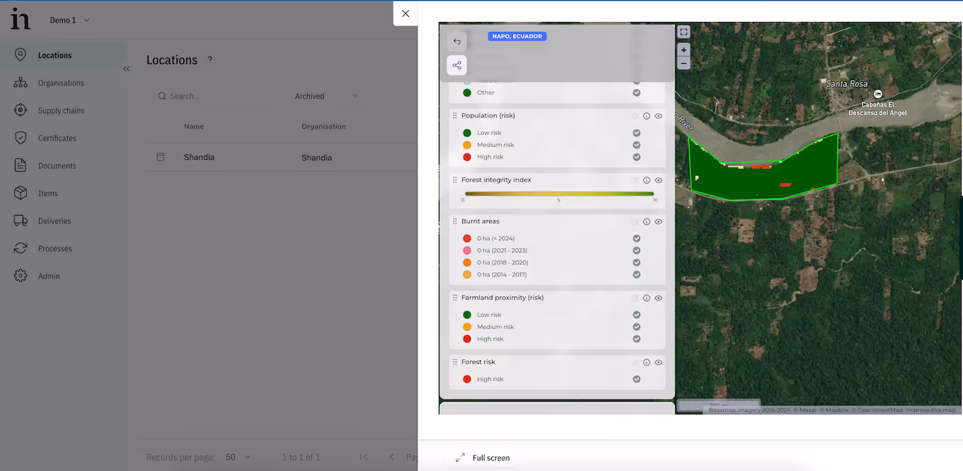
When assessing points of harvest for risk, stakeholders exhibit varying levels of proficiency with Geographic Information Systems (GIS). Some are adept at using public datasets from Global Forest Watch and the EU's JRC-managed observatory. Others seek additional guidance, leveraging a mix of public and private datasets for more precise and current insights. For an in-depth look at the advantages of different datasets, Satelligence provides valuable insights on this topic.
Given these diverse needs, we at iov42 have adopted a flexible approach with our traceability solution Interu, integrating with various providers chosen by our users, including our partner, Orbify. Orbify's cutting-edge geolocation satellite technology delivers state-of-the-art environmental insights, helping stakeholders meet regulatory standards. You can learn more about Orbify's solutions and their impact here.
Once geolocations are verified to be deforestation-free, they need to be uploaded into the EU’s Information System. Although the final details are pending, the EU has released an API for integration which we have been actively testing, with full implementation expected by December 2025. We are committed to minimising duplicate data entry for our users, and our integration with the Information System will be completed promptly after the EU provides more detailed specifications.
The road to EUDR compliance may be complex, but you don't have to navigate it alone. Partner with iov42 and our trusted collaborators to streamline your geolocation data management to help you meet regulatory requirements. Get in touch with us today to learn more about how we can support your journey towards a deforestation-free future.


.avif)